Roam Map turns location pages and blocks into live maps inside Roam. Choose places directly, collect them with a native query, or return exact page and block UIDs with Datalog. The map stays connected to its Roam sources and opens them in the right sidebar when you need the underlying notes.
Install Roam Places alongside Roam
Map. Roam Map renders location data; Roam Places is the recommended way to
create it. Its /Place command searches your graph and online place services,
then saves the coordinates Roam Map reads — no attribute editing by hand.
Everything below works without it, but every step is easier with it.
-
Give each place page a
Coordinatesattribute. The quickest way is the Roam Places/Placecommand, which saves this while you write. To add one by hand instead:roam/meta:: Coordinates:: geo:-20.1609,57.5012 -
Type
/mapand choose Map (Roam Map), or type{{map}}in a block. -
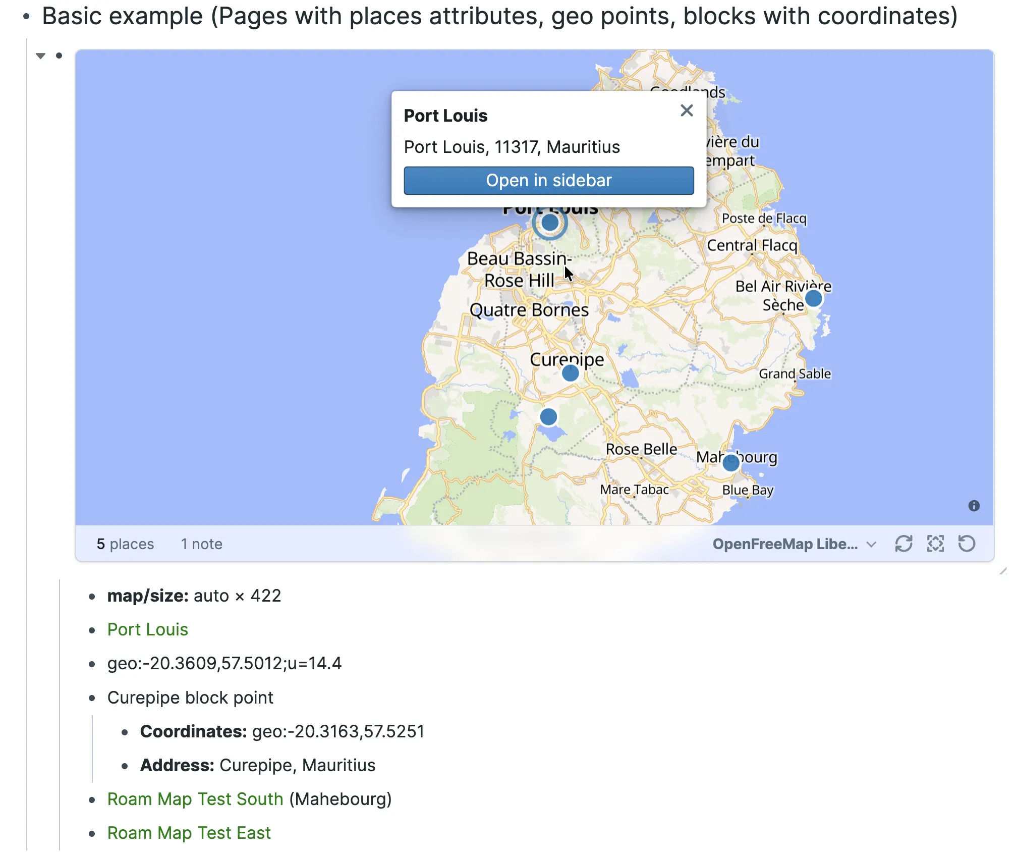
Add each place reference in its own descendant block:
{{map}}
  [[Port Louis]]
  [[Curepipe]]
Parent blocks can group places. Roam Map follows outline order, removes duplicates, and updates when known sources or their location details change.
A map can read:
- location page references;
- a bare
geo:latitude,longitudeblock; - a named block with a
Coordinateschild; - a native Roam query placed directly beneath the map; or
- a fenced Datalog query placed directly beneath the map that returns page or block UIDs.
For example, a native query can keep a map tied to changing graph content:
{{map}}
  {{[[query]]: {and: [[Efforts]] {search: roam/meta::}}}}
Native-query block results map through their containing page. Use Datalog when you need to select exact location pages or block-backed points. Press Refresh when an unrelated page may have started or stopped matching a dynamic query.
See the tested query and Datalog examples for copyable patterns, including relationship-aware maps.
- Click the place count to open a text-first results list. Selecting a row highlights and focuses its point; Open in sidebar returns to its source.
- Use Fit to frame the current places and Refresh to rerun all sources.
- Use the basemap menu to preview another style. Add a child such as
map/basemap:: OpenFreeMap Darkwhen the choice should be saved with the map. - Hover near the bottom-right corner and drag the resize grip. Roam Map saves
the result in one readable
map/sizechild; Reset map size restores the responsive default. - Click a marker for its label, address, overlapping places, and source action.
Map movement is intentionally temporary. Roam Map does not save pan, zoom, bearing, or pitch.
Coordinates uses a plain two-dimensional WGS84 geo: URI with latitude
first and longitude second. An optional u parameter records uncertainty in
metres. Roam Map can also render a GeoJSON Point from Geometry; lines,
polygons, and other non-point geometry are reported rather than drawn as
markers.
Address and Geocoder ID add useful place details. Other scalar attributes
can drive advanced MapLibre styling. Roam Map reads both current Roam
attributes and compatibility Attribute:: value blocks, including attributes
beneath an exact roam/meta:: child. Rendering never rewrites a source block
or location page.
OpenFreeMap Liberty is the default. Keyless alternatives include OpenFreeMap Positron, Bright, Dark, and Fiord, plus the attributed 2016 EOX Satellite Context mosaic.
Graph administrators can open Settings → Roam Depot → Roam Map → Basemap catalog to add a complete MapLibre style URL, an attributed raster tile template, or the optional MapTiler shortcut. Catalog settings sync with the graph: collaborators may be able to read configured URLs and browser keys, and providers receive those values in browser requests. Use restricted public browser keys, not secrets.
Opening a map loads styles, sprites, fonts, and tiles from its selected providers. Roam Map keeps required provider and OpenStreetMap attribution in the map. Reading pages, native queries, and Datalog results from the current graph does not contact an external search service.
Roam Map also supports data-driven MapLibre layers, image markers, reusable marker cards, and custom results lists. These are graph-authored code and presentation resources rather than extra location fields.
Enable Roam's custom-components setting before using graph-authored JavaScript, JSX, or Clojure components, and treat that code as trusted graph content.
- Maps render points; lines, polygons, clustering, and arbitrary authored GeoJSON sources are separate capabilities.
- Dynamic membership comes from native queries or fenced Datalog, not search
components, saved
:qcomponents, or{{map: ...}}arguments. - Roam Map does not geocode, classify, or rename sources. Use Roam Places or edit the location page directly.
For local development:
npm install
npm run dev
npm run check
Load the repository through Settings → Roam Depot → Load local folder.